 Shredlytics
Click a trail, lift or lodge for its status, today's conditions and reviews. Hold ⌘ or Ctrl to zoom with the scroll wheel.
Terrain
- 10 easiest
- 10 more difficult
- 6 most difficult
- 8 experts only
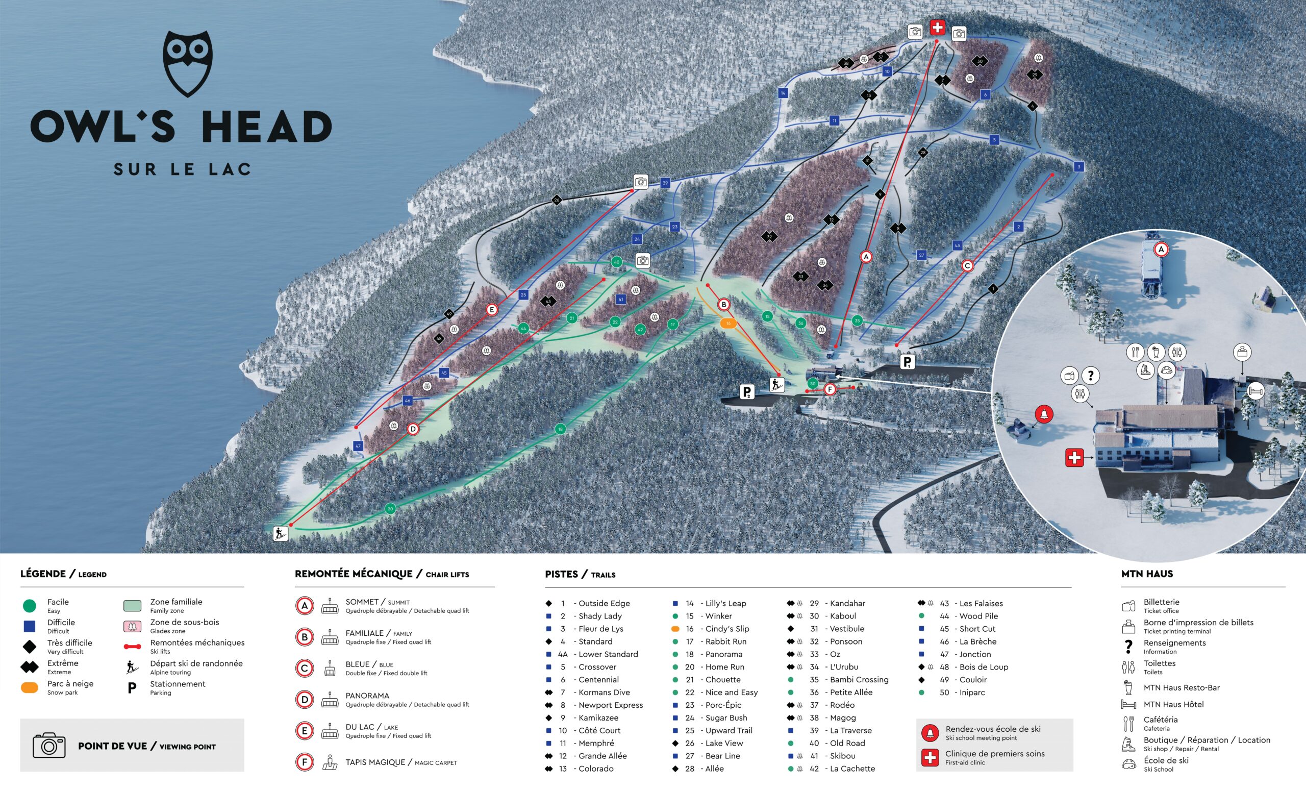
Named trails on our map of the mountain, by the sign on the resort's own map.
Elevation
Base 786 ft to summit 2,362 ft, on the same scale as every resort in the list (16–13,487 ft).
Uphill travel
Alpine touring (randonnée alpine) with an access ticket or touring pass at all times. 8:30 a.m.–4 p.m.: climb only on the official ascent trails of the map (Petit Duc, Harfang des neiges, Grand Duc, Hulotte, Chevêche, Oural), ski down open marked trails. 6–8:30 a.m. and 4:30–8 p.m.: the ascent trails and the designated trails (Lilly's Leap, Porc-Épic, Chouette, Nice & Easy, Winker, Panorama, Home Run, Upward Trail, La Traverse, Outside Edge), up and down; not patrolled (911). Nobody on the mountain 8–8:30 a.m. or 8 p.m.–6 a.m.; no pre- or post-season touring; a white front light in the dark; no crampons or snowshoes; no dogs.
At a glance
- Lifts
- 5 chairs, 1 carpet
- Night skiing
- No (lifts 8:30 AM – 4 PM)
- Terrain parks
- 2
- Passes
- Indy+ Pass · 2 days
- Indy Base Pass · 2 days · blackout dates
- Trail map
- The resort's official map
- Tickets
- Tickets & passes
- Phone
- 450 292-3342
- Ski patrol
- 1-450-292-5000
- Address
- 40, chemin du Mont Owl's Head, Mansonville (Québec) J0E 1X0
Compare with a neighbor
- Mont Sutton13 mi · 1,500 ft
- Jay Peak Resort14 mi · 2,112 ft
- Mont-Orford17 mi · 1,933 ft
- Bromont, montagne d'expériences22 mi · 1,170 ft
Lifts and trails
Loading the latest from the resort…
Trail and lift data © OpenStreetMap contributors, via OpenSkiData (ODbL), with additional information from resort sources. Resort facts include information from resort and pass-provider sources. Catalog built 2026-11-01. Trail and lift counts reflect our catalog and may differ from resort totals. Check official resort sources for current closures, access and pass terms. Something wrong? Tell us.